This National Surveyors Week, we’re celebrating one of the greatest land surveying projects ever completed: The Great Pyramid of Giza.
Surveyors pave the way for development, so it’s no surprise that land surveying is one of the oldest professions out there. While a lot has changed, some aspects of surveying are the same as in 2550 B.C. when the Great Pyramid was built.
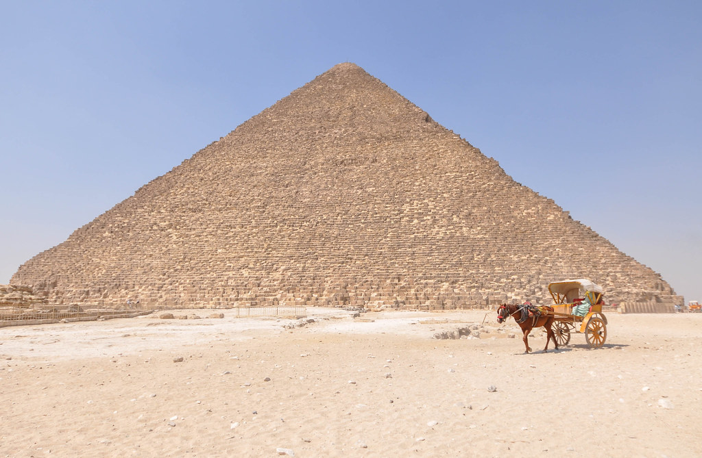
The monument is one of the Seven Wonders of the Ancient World, and it’s no wonder why — it’s a gorgeous and awe-inspiring feat of architecture. The biggest question, however, is how the pyramid was built. We know that enslaved people in Egypt did the labor, and many died from the intense physical exertion they were forced to undergo. The planning and design behind the pyramid, however, throws most historians for a loop.
Egyptians first utilized land surveys to mark land plots using rope. This was to aid with taxation, but because seasonal floods would often wash away the boundaries between land, it also helped clarify the property lines. This is similar to what many surveyors do now, as a land survey is usually needed to assess property value, settle property disputes, and apply for mortgage rates and loans. These early surveyors were called harpedonaptae, meaning “rope stretcher.” Their main tools included geometry and a plumb bob (a weight on a string), which surveyors still use today.
Just like modern surveying combines science, math, and history, ancient surveyors relied on multiple disciplines to design the Great Pyramid. No part of the pyramid’s design was an accident or coincidence. For example, the four sides of the pyramid’s base are closely aligned to the four cardinal directions. These measurements are off by approximately 1/10 of a degree, on average. That’s shockingly accurate! No wonder contemporary surveyors are still impressed by the Egyptians’ techniques.
To accomplish this, historians think the Egyptians employed the Solar Gnomon Method, which tracks the movements of the sun using shadows, like a sundial. But when the sun set, the work didn’t stop; the Egyptians turned to astronomy, noting the polar star and other stars that make a vertical line on the horizon. Those measurements guided the alignments at the base of the pyramid.
Tools like a merkhet helped the Egyptians make sense of the night sky. A merkhet is a plumb bob attached to a wooden handle. Along with a bay, which was a sighting tool made from a palm leaf, Egyptians used the merkhet to indicate north, like a compass, as well as to track the stars’ movement across the sky to measure time and find alignments. Today’s level, a household tool, is a derivative of the merkhet. Surveyors often use levels — hand levels, laser levels, Abney levels, and more — in their work, and sighting tools similar to bays are vital to surveying. Indeed, the most common tool in modern surveying is the theodolite, a telescope that measures angles by aligning with a measuring stake — not unlike a merkhet and bay.
The actual construction of the pyramid, with wide blocks stacked and tapering off into smaller blocks at the top, is another master design. The ancient Egyptians used a grid system to do this. Think of a map of Manhattan, with its intersecting streets. Determining each block’s grid coordinates is like following these modern-day maps. Instead of solely relying on the grid, surveyors today would probably use a theodolite and tape measure to calculate these points.
Some contemporary tools, though, are remarkably similar to what was used to build the pyramid. Have you ever noticed lines of chalk on the ground near a construction project? This technique (called “snapping a line”) marks straight, long lines, which help builders plan the sizes of structures and the distance between them. Believe it or not, this technique originated in ancient Egypt, and not much has changed since then!
While we still utilize ancient surveying techniques, technology has changed much of what modern surveying looks like. Ancient Egyptians used angles and weights to measure distances; today, we use lasers. A method called lidar manipulates lasers to send out light pulses, and a sensor measures how long it takes the light to return. This helps surveyors calculate the distances between different structures. Using lidar, a surveyor can quickly know the 3D map of an entire area, including different elevation points and moving objects. (Lidar sensors also play a key role in the continued development of self-driving cars.) Photogrammetry, which analyzes photographs to map out 3D information, is used to survey properties that are only visible from the sky. Hydrography helps survey the floor of a body of water. GPS and 3D laser scanning technologies, perhaps the most influential advances, give land surveyors a complete view of a property and guide them as they draw their plats. Just as surveyors lead our progress, the profession itself is progressing, too.
Though we don’t know all the surveying techniques that were used in ancient Egypt, the Great Pyramid of Giza shows how effective these tools were. The measurements, angles, and planning are remarkably accurate, and the construction is a feat of its own. It might serve as a resting place for one of Egypt’s most well-known pharaohs, but the pyramid is a signal of growth rather than death.
Luckily, whether it’s the projects they work on or the surveying profession itself, growth is what surveyors do best. Who knows? Maybe the world’s next great surveying project is already in the works.